数据模型
包括:地理时空与几何代数空间的映射模式,地理过程连续-离散一体化表达模式,场景数据模型,地理规律驱动的GIS数据结构与索引。


包括:地理时空与几何代数空间的映射模式,地理过程连续-离散一体化表达模式,场景数据模型,地理规律驱动的GIS数据结构与索引。
包括:新型GIS计算框架;计算模型算子库;分析流程统一的结构化模板;脚本化模板开发方法;算法解析优化与并行化。
包括:地理模型模式的自适应集成与改造;动态模型的GIS计算嵌入;结构化特征模型的GIS计算嵌入;连续地理模型GIS计算嵌入。
包括:系统架构;计算算子库;计算引擎;系统功能与截图;典型分析案例(三维城市案例、南极海地冰案例、应急疏散案例等)。
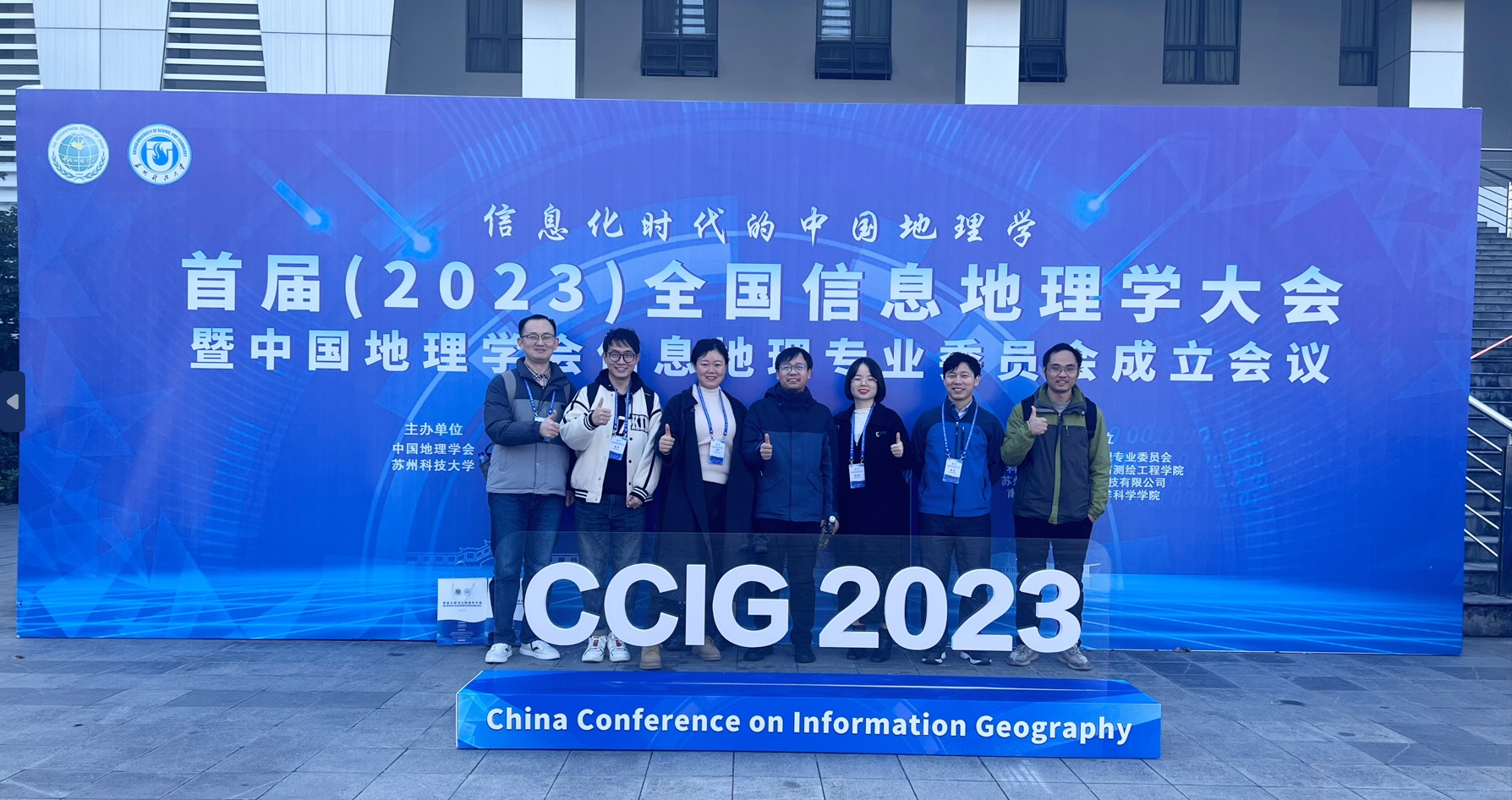
2023年11月18-19日,由中国地理学会和苏州科技大学共同主办的“首届全国信息地理学大会暨中国地理学会信息地理专业委员会成立会议”在苏州召开。本次大会以“信息化时代的中国地理学”为主题,俞肇元教授、罗文教授、李冬双副教授、硕士生黄亚迪共同参加了大会。其中俞肇元教授作了“从二元空间到三元世界:信息地理学中空间与对象的重构”主题的报告,罗文教授作了“地理信息场景一体化表达与计算的范畴学方法”主题的报告,李冬双副教授作了”AI for Ocean Science”主题的报告。
2023年11月14-17日,赵彬如副教授参加了由International Consortium on Landslides在佛罗伦萨和意大利主办的第6届 World Landslide Forum,并在论坛作了”Assessing the potential of different satellite soil moisture products in landslide hazard assessment”的汇报。
2023年11月9-12日,俞肇元教授、罗文教授、李冬双副教授、博士生杜沛、王建在厦门参加了由联合国海洋十年计划项目组主办的第二届国际数字孪生海洋峰会,本次峰会围绕感知、模拟、可视等主题,会议中俞肇元教授作了”A Scenario-based Information Integration and Interaction Framework based on Large Language Model for Ocean Digital Twin System”的报告,罗文教授作了”Multi-dimensional and multi-level complex network model for expressing game relationships among stakeholders in coastal zones”报告,杜沛博士作了”The Construction Patterns of Data Management Framework for Digital Twin system in Coastal Region”的报告。
2023年11月3-5日,由中国测绘学会摄影测量与遥感专业委员会、武汉大学遥感信息工程学院主办的摄影测量与遥感2023学术年会在上海举行,赵彬如副教授参加了会议并作了“顾及城市建筑精细结构的城市内涝模拟”主题的报告。

Irregular geographic spatio-temporal-field data have been rapidly accumulating; however, data organizations and operations for different irregular types are often segregated, leading to systematic drawbacks, such as interface expansion difficulty and high coupling codes in GIS implementations. The paper proposes a unified approach to organizing and operating irregular geographic spatio-temporal-field data. The proposed approach has two components, namely ‘concepts and definitions’, and ‘logical model’. The first component introduces the concept of primitive elements, which are formal sets of data points, to serve as the smallest building blocks in the data organization. We define the corresponding primitive elements for three prevalent irregularity types (including sparse, imbalanced, and heterogeneous). The second component utilizes object-oriented programming to support the implementation of various operators. Additionally, we develop the layered architecture to decouple data organization, operation, and visualization to assure low coupling among layers. For demonstrations, we conduct case studies to show the effectiveness of our approach. Additionally, we conduct experiments to new irregularity types and illustrate the flexibility and scalability of our approach. Comparisons with classic tensor methods and spatio-temporal analysis methods show that our approach has more comprehensive supports for different data types.
At small granularity (e.g., 10-minutes to hourly), expressway traffic volumes rely heavily on drivers' driving habits heterogeneity and decision randomness, making it challenging for accurate modeling. In this paper, we propose a small granularity simulation model named Small-Granularity Expressway Traffic Volumes with Quantum Walks (SGETV-QW). The proposed model adopts quantum walks to generate probability patterns of the exiting time of drivers from the expressway. Then, we refine and map the generated probability patterns to empirical traffic-volume data via a stepwise regression and quantify the modeling accuracy in both the time and frequency domain. We validate SGETV-QW for traffic volume data from seven stations along the Nanjing-Changzhou Expressway in China and compare it with Autoregressive Integrated Moving Average Model (ARIMA) and Long and Short-Term Memory (LSTM) networks. The results show that SGETV-QW improves the simulation accuracy at small granularity. In addition, traffic volumes simulated by SGETV-QW have almost the same frequency spectrum as observed traffic volumes. Finally, we conduct a sensibility analysis and show that SGETV-QW can adapt its parameters to model traffic volumes at different granularities.
Lossy compression has been applied to the data compression of large-scale Earth system model data (ESMD) due to its advantages of a high compression ratio. However, few lossy compression methods consider both global and local multidimensional coupling correlations, which could lead to information loss in data approximation of lossy compression. Here, an adaptive lossy compression method, adaptive hierarchical geospatial field data representation (Adaptive-HGFDR), is developed based on the foundation of a stream compression method for geospatial data called blocked hierarchical geospatial field data representation (Blocked-HGFDR). In addition, the original Blocked-HGFDR method is also improved from the following perspectives. Firstly, the original data are divided into a series of data blocks of a more balanced size to reduce the effect of the dimensional unbalance of ESMD. Following this, based on the mathematical relationship between the compression parameter and compression error in Blocked-HGFDR, the control mechanism is developed to determine the optimal compression parameter for the given compression error. By assigning each data block an independent compression parameter, Adaptive-HGFDR can capture the local variation of multidimensional coupling correlations to improve the approximation accuracy. Experiments are carried out based on the Community Earth System Model (CESM) data. The results show that our method has higher compression ratio and more uniform error distributions compared with ZFP and Blocked-HGFDR. For the compression results among 22 climate variables, Adaptive-HGFDR can achieve good compression performances for most flux variables with significant spatiotemporal heterogeneity and fast changing rate. This study provides a new potential method for the lossy compression of the large-scale Earth system model data.

Due to the increasing complexity of GIS data and service modes, there is an urgent need for the next generation of GIS with new representation and computation methods. A number of spatiotemporal models, analytical and visualization methods, as well as system architectures have been proposed. However, previous studies failed to integrate basic geographical theories with latest computing technologies. Without a well-defined body of underlying theories, new models and methods are limited in scope and not able to meet the ultimate requirements of the next-generation GIS, which demands multidimensional, highly dynamic and semantic-rich representations and computational power. Geometric algebra (GA) provides an ideal tool for the expression and calculation of multidimensional geometric objects, and has proved to be effective for GIS representation and computation applications in our previous studies. We propose to use GA as the basic mathematical language for the establishment of the next-generation GIS. We present the framework of a GA-based next-generation GIS and describe the representation space, data structure, and computational models in this paper. A few issues that have not been sufficiently addressed by previous studies are discussed in detail with potential solutions proposed. These include multi-scale representations, modelling of geographic processes, simulation of geographic interactions, and multi-element modelling. The GA-based next-generation GIS uses an integrated structure consisting of a theoretical architecture, model for information expression, and computational methods. Implementation of the approach aims to improve GIS capacities in applications such as global spatiotemporal modelling and analysis, regional geographic modelling and simulation, smart city applications, and many others.